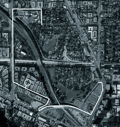
This map of the area near our apartment (the white circle) shows how close we are to a park. The park is split into two sections, north and south of the river. Even though we are so close, it's a long way to get to either part because the park is on the other side of the freeway - the white lines show how we have to get there.
We drove to the north side last week, and yesterday we walked/rolled to the south part. It was a bit of a haul, and steep going over the freeway, but it was worth the effort to get there. The little street on that side of the freeway, right in the southwest corner of the park, is actually our street, so before the freeway was put in the park would have been just a couple of minutes away. Oh well, at least this way I'll get some extra exercise.


3,000 or so balloons should do it.
ReplyDeleteI got tools dont forget!! we can just remove the part of the freeway thats in the way!!
ReplyDeleteIm sure Marty and Petey will be up for some demo!! Teach em to mess with us Canadians!!
$
Demo? Pffft. Couple of ramps. A jet pack and a parachute. Done. Why inconvenience a couple of million people when we could have some real fun? Think of the headlines!
ReplyDeletePete